Early in the life of this (still youthful) blog, I had a short throwaway post about Modes of Representation – and echoed a term I had heard regarding ‘visual masturbation’ – the analogue of the pointless drivel associated with verbal masturbation. While there are still countless examples of both in the design and planning spheres – a 2008 article in the NY Times, and my reading of more of his work solicits the following reaction. I will officially recant my words specifically a quote referencing Alan Berger, and posit that ‘Drosscape: Wasting Land In Urban America’ (2007) is a vital addition to the library of any landscape urbanist, landscape architect and planner.

:: image via Frieze
As I’ve sat with this half-written post in my drafts folder for going on six months, I thought it time to delve into some discussion on the book. It is long overdue, but perhaps gave me some to reflect further on the power of the image tied to the idea. Upon further review (i.e. reading versus looking at images) the book has some heady and important ideas that need to be not just digested, but discussed. The idea of Dross (waste) landscapes are important from a number of perspectives including the ‘how’, ‘where’ and ‘why’ of their creation, and also the ‘what’ and ‘when’ of their potential redevelopment.
The references of drosscape have some powerful precedents – most notably tied to Lars Lerup’s ideas of Stim and Dross, which are very engaging ways of thinking of space not just as a physical entity, but as catalytic actors in urban fabrics. What they cause and create is perhaps more important that what they actually are. Stim (a shortened version of stimulus) countered with Dross (the idea of waste landscape), in tandem create tension and opportunity, where most of us see blight. And the reality is that they are difficult if not downright impossible to eradicate – but will continually emerge and re-invent themselves as an inevitability of growth.

While it is evident that dross is ubiquitous in the world – the particular mechanisms that cause the phenonmenon, specifically in the United States, is quite complex. This is where the visual acuity of the book is pretty impressive – not obfuscation, but the synthesis of many layers of complex data into graphics that are both artful and full of information as well. To discuss representation for a bit, the middle part of the book contains mostly visual case studies analyzing Drosscapes and their emergence along a number of specific and time-critical paths. These are evident in case studies of a range of US metropolitan areas, allowing for similar comparison of ideas to give the proper context of urban form and development.
A major facet to the book, which should intrigue those with a penchant for Landscape Urbanism, is the representation of time in a variety of forms. Temporality is difficult if not impossible to capture in two-dimensional imagery, and Berger does a bang-up job of overlaying typical plan graphics of cities, such as Chicago above, along with complex data showing outward expansion over time. This is coupled with more traditional data streams (line charts, bar graphs, etc.) that are juxtaposed artfully over space – becoming not just another level of information, but part of the data stream and context. The subseqent addition of aerial photographs showing areas of focus allow one to connect the complex mapping and data analysis to real place.
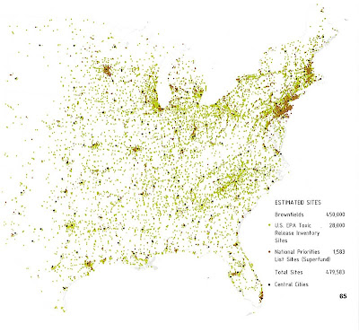
Another diagramming exercies that worked well in driving home the mechanism of sprawl is the bar charts overlaid upon the metropolitan urban form. These spindle charts show a temporal shift in manufacturing jobs – in the case above from Chicago – concentrated in the beginning within dense urban cores, and slowly migrating further and further away from this center – creating the iterative and expanding framework in which dross will inevitably creep. There are also more overt images – such as those below of entropic indicators, as well as urban cores to sites of pollution concentration – showing straight causality between urbanism and blight or sprawl landscape.
Sometimes the imagery is utilized for storytelling – again with a temporal bent. In the example below, the juxtaposition of urbanized area desnity to total population – showing that from 1950 to 2000, density (in overall persons per square mile) has decreased by 50 percent. And the photo within the graphic frame shows some of the results – much more powerful than what’s standard on your excel spreadsheets… 🙂
Precursors of this are Berger’s visually stunning ‘Reclaiming the American West’ (2002) and the more pithy related ‘Taking Measures Across the American Landscape’ (2000) by Corner & MacLean – both of which rely on oblique aerial photography to understand the patterns of development in our landscape. Drosscape was chosen one of the top 10 planning books of 2007 by Planetizen, and it’s well deserved: “Drosscape is a fascinating visual examination of the modern built environment. Chock-full of photographs, maps and charts, the book exposes readers to the ‘wastelands’ of ten different American cities -– from older industrial areas in the urban core to modern complexes on the metropolitan fringe. While the book takes a mostly negative view of sprawl, it serves not as a condemnation per se, but as fertilizer for the germination of ideas regarding the productive reuse of these underutilized and spoiled landscapes.”
The challenge of new modes of representation (and language and thought) is one that continues to challenge our assumptions about appropriate content for design, illustration, and graphics. While some (including myself) are resistant to these new forms – they become necessary to illuminate complex forms of thought. Landscape urbanist theory regarding the appropriate representation of process – including four-dimensional aspects in a two-dimensional media, are sometimes difficult to grasp – but are necessary if we are to truly understand the complexities of our urban areas. Dig in, it’s worth the time.


